+JMJ+
AMDG
The San Gorgonio Wilderness...

Land of wondrous lakes, monumental snow-capped peaks, lush, verdant forests and meadows, narrows, perilous canyons, gentle valleys and raging streams: A wonder of God's Design. It is for these reasons that nature enthusiasts have been traversing the bountiful terrain in numbers of the millions during the last century and a half. The west sides of the wilderness are prevailed by Southern California's classic vegetation, chaparral, a mixture of miniature trees and bushes, together with scattered pines and firs every so often. To the east reveals a desert paradise holding pinyons, junipers, joshuas, cactus, rugged and dangerous terrain, as well as scarcely visited, Whitewater Canyon, an awesome formation resembling that of Utah and Arizona. And in between those two expose the most impressive regions in Southern California. Verdant pastures and forests are absolutely compelling things to experience. An Aspen Grove beckons those who are reminiscent of the gently swaying, quaking trees. Four lakes surround the high country, marking but another amazing feature of God's bountiful and indescribable beauty of HIS Creation. Numerous peaks soar over the 10,000' mark, providing a wondrous backdrop to the wilderness. And finally, recognizable in distances as far as 100 miles away, is Mount San Gorgonio, marking in at 11,512' above sea-level. It is the tallest peak in Southern California, and until Canada is the tallest in the Pacific Coast Range, which extends from the tip of Baja California up to Southern Alaska. As you can plainly see, this is the nature crown jewel of Southern California, it shall forever remain a wilderness lost in God's bountiful time.
Let the Creator be Praised.*
-------------------------------------------------------------------------------------------
Last year, I attempted to summit Mt. San Gorgonio, which at 11,503' is Southern California's highest peak. No other summit comes close to challenge it's height for over a hundred miles around. The farthest part I made it to was Trail Flats Campground at 9,600'. I was not very prepared, for the trip was my first backpacking experience, but now, with considerably more planning, training, and prayer, the long two year wait to conquer the summit was over.
I hiked to the summit via the Dry Lake route in 3 days and 2 nights along with my father, sister, my friend and his dad. Here are the basic statistics:
TOTAL:
MILES: 24
ELEVATION GAIN: 4,700'+
CATEGORY: DEATHLY EXTREMELY STRENUOUS ( 1 DAY),
EXTREMELY STRENUOUS (2 DAYS), STRENUOUS (3 DAYS)
LOCATION: SAN BERNARDINO NATIONAL FOREST, SAN GORGONIO WILDERNESS
PERMITS: ADVENTURE PASS AND WILDERNESS PERMIT REQUIRED
DAY 1:
Date: Monday, July 22, 2013
Itinerary: Start at South Fork Trailhead and end at our campsite at Dry Lake
Start time: 9:05 AM
End Time: 2:30 pm
Total Time: 5.5 Hours
Miles: 6.2 (ONE-WAY)
Elevation Gain: 2,200'
DAY 2:
Date: Tuesday, July 23, 2013
Itinerary: Leave the heavy gear at Dry Lake Campsite, and daypack to the summit, and come back to camp.
Start Time: 8:11 AM
End Time: 5:11 PM
Total Time: 9 Hours (5.5 hrs going up, 3.5 hrs coming down)
Miles: 12.5 (Round trip from Dry Lake to Summit and back to Campsite)
Elevation Gain: 2,500'
DAY 3:
Date: Wednesday, July 24, 2013
Itinerary: Pack up our backpacking gear and head back to the parking lot.
Start Time: 9:55 AM
End Time: 2:40 PM
Total Time: 4 Hours, 45 minutes (slow pace)
Miles: 6.2 (One-Way)
Elevation Gain: Almost all downhill, maybe 100' of gain.
------------------------------------------------------------------------------------------------------------
Here is the Trip Report:
Directions: From the I-10 East in Redlands, exit Orange St turning left onto it (Hwy-38) and continue on it. Then turn right onto Lugonia Ave, which becomes Mentone Blvd. and Mill Creek Road after about 5 miles. (Pick up a permit at the Mill Creek Ranger Station open Wed-Sun. 10-4.) Continue on CA-38 through Mill Creek Canyon and up some windy turns up to Angelus Oaks. Continue about 20 min to a small street sharply on the right called Jenks Lake Rd West, and stay on it for 10 minutes, until you reach the South Fork Trailhead.
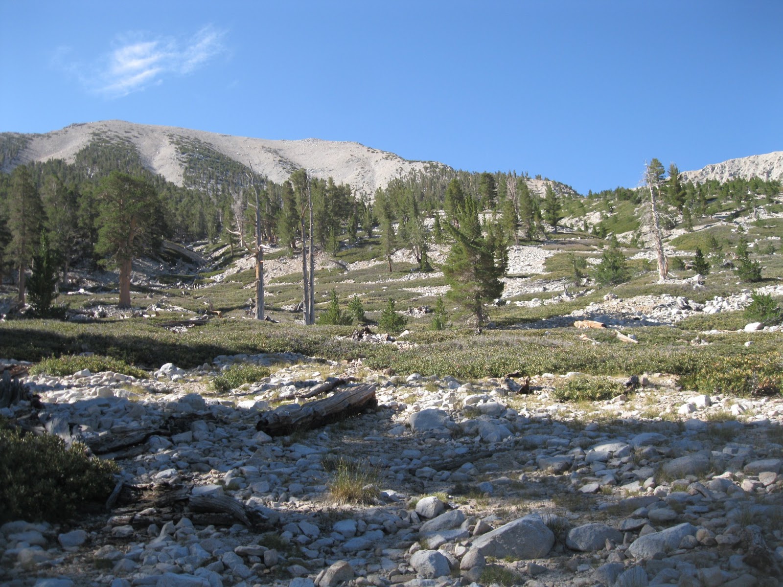
 Description: This hike, by far is the best hike possible in Southern California in my opinion. The trail starts high in the scenic and verdant San Bernardino Mountains in the main forest body, comprised of Ponderosa, Jeffery, Sugar Pine, White Fir, Interior Live, and California Black Oak at 6,880'. Gradually along the trail you pass several meadows, a spring, and attain views of the steep Santa Ana Canyon Divide across from you culminating at Sugarloaf Mountain. Once at Poop-Out Hill, you can make the brief dash to it's summit to glimpse the first view of San Gorgonio Mountain, treeless before you miles away. Enter, the Wilderness, pass the aftermath of avalanches, and find yourself praising the the Creator at the headwaters of the Santa Ana River. Climb the rocky switchbacks to beautiful Dry Lake, and continue through the Sub-Alpine forest to Mineshaft Saddle. Walk around the plane wreckage of a C-47 USAF fighter, climb the 10 switchback to 11,000', and cross over the south side of the mountain and its surrounding peaks, as you enter the surreal Alpine Tundra of Southern California. And finally summit that famed peak, Mt. San Gorgonio.
DAY 1:
We started at the South Fork Trailhead at 9:05 AM, and continued at a good pace until Horse Meadows (1.5 miles, 300' gain), where we breaked and rearranged our packs. Next we climbed through the rocky Chaparral zone and then entered to lush Rainbow Meadows (I named it that) and a spring. We crossed into the San Gorgonio Wilderness (2.5 Miles, 860' gain) and headed along the pathway to 2 areas wrecked with havoc from avalanches. At 3.7 miles and 1500' above the parking lot, we reached South Fork Meadows, a perfect lunch spot. After our delicious lunch we made the grueling switchbacks up the Dry Lake Trail which gain 800' in under 1.5 miles. After the switchbacks we entered a small canyon and walked alongside it until we beheld Dry Lake (though it could be anywhere from a lake to a marsh, meadow or sandpit). At the junction at the lake we went left and walked to Dry Lake Trail Camp. It was 2:30 PM. 5.5 Hours later. Plenty of time to set up camp draw water from nearby Lodgepole Spring (get a good map to find it), and cook our MOUNTAIN HOUSE Macaroni dinner with hot dogs. Lights out for the big day tomorrow at 9 PM. 3
To find Lodgepole Spring walk past the Dry Lake camp and follow the trail that goes ABOVE the lake and follow the sign pointing towards the spring. Charge through the wash and stay on the LEFT (NORTH) side of the Canyon for about 5 minutes until you find the tricking creek.)
DAY 2:
Breakfast of Oatmeal, Pop-Tarts, an orange and apple at 7 AM. We filled our backpacks with gear we only need for the day, which was for me, lunch snack, a long- sleeve shirt, a hoodie (I was wearing a short sleeve and cut-off pants), random gear, and about 150 oz of water.
We left our 'Base Camp' at 9:05 AM after Morning Prayers, and charged across Dry Lake to the Trail on the SOUTH side of the Lake. We struggled up the bouldery slopes up to Trail Flats, and then to Mineshaft Saddle (9,920') by 10:05 AM (2 Miles and 900' from Dry Lake). From here we took the trail to the right along the ever tree-thinning mountainside, through extremely steep unending territory for 1.5 miles. When we past the C-47 wreckage, we prayers for the soldiers' souls, and then continued on shortly to the switchbacks. Right before the first one, we took lunch break at 11 AM. After Lunch we switchbacked up the Northeast face of the mountain, which in 45 minutes ended at 11,000' (the switchbacks gain about 600'). From here we walked
the remaining 500' (the longest and hardest of my life), through the Alpine Tundra, past the large ditch called The Tarn to our left, and overtaken by Bighorn Peak behind it. We past by the precipitous Dragon's Head Mountain, which is literally probably at an 70 degree angle or more. Wow! This terrain looks like the High Sierras! The Trail crossed up towards the peak to the Summit Plateau and then we took the trail right at the junction (11,360'), and followed the sign that pointed right to San Gorgonio Mountain. From there we walked across the Summit Plateau to the rocky summit of Mt. San Gorgonio (11,503') , and savored in the glory of God's Creation. The temperature probably felt close to 40 F on summit (wind, and drizzle- no views). We got to the summit at 1:30 PM, and left around 1:50, returned to the camp by 5:15 PM. In time to make dinner collect more water, and pray the Rosary and Chaplet of Divine Mercy.
A good breakfast Oatmeal, Pop-Tarts, tea, and fruit. We left camp at 9:55 AM, and arrived at the car at 2:40 PM. Basically the same as day one! We just walked down! A beautiful, slow paced walk back to the car.
-------------------------------------------------------------------------------------------
Overall Conditions:
 Weather: Cloudy most of the time, with just a few sprinkles, and dew in the morning. Temperatures felt as low as 40 F on summit (with wind chill), to 75 F in the daytime on the last day near the car. The average temperature at night (between 7 pm-9am) was 45-55 F at Dry Lake. In the Day it was 55-70 F. The coldest at night it ever got was 45 F.
 Trail: You need a good sense of direction and a good topographical map. In some places (especially near Trail Flats), the trail unmaintained. The trail for the most part is quite rocky and rough, but not terribly steep. (unlike Mt. Baldy)
Food: Mountain House Freeze Dried food (Macaroni and Cheese, Rice and Chicken, and Chicken Alfredo), hot dogs, Oatmeal, Pop-Tarts, Spam, oranges and apples, and other snacks.
Food List :
- Cheetos/chips
- Apples (4), Oranges (4)
- Trail Mix
- Granola Bars
- Chocolate bars/candy
- Chocolate and Vanilla Pudding
- 'Italian” Orowheat Bread Loaf
- Peanut Butter
- Grape Jelly (food saved)
- Cheddar Cheese
- Instant Oatmeal (6)
- Hot Dogs (5)
- Spam Container
- ‘Mountain House’ Rice and Chicken
- 'Mountain House' Chicken Alfredo
- 'Mountain House' Macaroni and Cheese
- Roast Beef (for sandwiches the first day)
- Powdered Juices
- Instant Coffee and Creamers/Sugar
- Ritz Crackers
- Pop-Tarts
ESSENTIAL GEAR:
Flashlights
Medicines (Tylenol, Motrin, Advil, Benadryl [ we used benadryl for sleeping] )
Backpacking Pillows (3)
Gel
shovel/toilet paper
Gel wipes
Water Filtration or Tablets
Water Containers
Compass
Lighter and matches
Rags (for cleaning)
Camp Soap
Sunscreen
Extra Clothing
A good sleeping bag (a 30 F bag at least)
Tent (not too heavy)
- First Aid Kit (necessary)
- Rope to hang a Bear Bag in a tree (mostly to keep the chipmunks out)
---------------------------------------------------------------------------------------------
Blessed John Paul II, Blessed Pier Giorgio, Blessed Junipero Serra, Saint Giana Molla, Saint Mary Magdelen, Sain Bridget, and Saint Sharbel Makluf, Pray for us!!!!!
Thank you to ALL Who prayed for us to have a safe and blessed trip!!!!!
Thank you Blessed Mother Mary, to whom we entrusted our entire trip!!!!


 Description: This hike, by far is the best hike possible in Southern California in my opinion. The trail starts high in the scenic and verdant San Bernardino Mountains in the main forest body, comprised of Ponderosa, Jeffery, Sugar Pine, White Fir, Interior Live, and California Black Oak at 6,880'. Gradually along the trail you pass several meadows, a spring, and attain views of the steep Santa Ana Canyon Divide across from you culminating at Sugarloaf Mountain. Once at Poop-Out Hill, you can make the brief dash to it's summit to glimpse the first view of San Gorgonio Mountain, treeless before you miles away. Enter, the Wilderness, pass the aftermath of avalanches, and find yourself praising the the Creator at the headwaters of the Santa Ana River. Climb the rocky switchbacks to beautiful Dry Lake, and continue through the Sub-Alpine forest to Mineshaft Saddle. Walk around the plane wreckage of a C-47 USAF fighter, climb the 10 switchback to 11,000', and cross over the south side of the mountain and its surrounding peaks, as you enter the surreal Alpine Tundra of Southern California. And finally summit that famed peak, Mt. San Gorgonio.

 the remaining 500' (the longest and hardest of my life), through the Alpine Tundra, past the large ditch called The Tarn to our left, and overtaken by Bighorn Peak behind it. We past by the precipitous Dragon's Head Mountain, which is literally probably at an 70 degree angle or more. Wow! This terrain looks like the High Sierras! The Trail crossed up towards the peak to the Summit Plateau and then we took the trail right at the junction (11,360'), and followed the sign that pointed right to San Gorgonio Mountain. From there we walked across the Summit Plateau to the rocky summit of Mt. San Gorgonio (11,503') , and savored in the glory of God's Creation. The temperature probably felt close to 40 F on summit (wind, and drizzle- no views). We got to the summit at 1:30 PM, and left around 1:50, returned to the camp by 5:15 PM. In time to make dinner collect more water, and pray the Rosary and Chaplet of Divine Mercy.

 Weather: Cloudy most of the time, with just a few sprinkles, and dew in the morning. Temperatures felt as low as 40 F on summit (with wind chill), to 75 F in the daytime on the last day near the car. The average temperature at night (between 7 pm-9am) was 45-55 F at Dry Lake. In the Day it was 55-70 F. The coldest at night it ever got was 45 F.
  Trail: You need a good sense of direction and a good topographical map. In some places (especially near Trail Flats), the trail unmaintained. The trail for the most part is quite rocky and rough, but not terribly steep. (unlike Mt. Baldy)


No comments:
Post a Comment