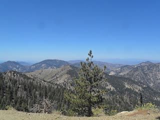
For those hikers who enjoy treks along high ridges and steep and rocky terrain, Mount Baden Powell (9,407') from Crystal Lake is for you. It is a 17 mile round trip, with a 4100' gain (some of it on the return), making it only for those in good condition. But, if you can do it, you will not be sorry the views are absolutely amazing. To the south is the Los Angeles Metro area, with the glistening Pacific and to the north the endless Mojave and the Southern Sierra. All around in the sublime high country of the San Gabriel Mountains, untouched here by civilization. This is a blissful hike in God's majesty.
---------------------------------------------------------------------------------------------
Statistics:
Category: Very Strenuous
Miles: 17
Elevation Gain: 4500'
Location: Angeles National Forest, Sheep Mountain Wilderness
Passes Needed: Adventure Pass for parking at Crystal Lake Campground.
Time: 10 Hours
Directions: From the I-210 in Azuza, exit CA-39 (Azuza Ave) and follow it 30 minutes from the freeway into the mountains, after some upgrades, take CRYSTAL LAKE ROAD on your right (just before Ca-39 ends), and take this road until in ends at Crystal Lake Campground. Park here.
Description: This is a gorgeous hike in the Chaparral, forest, burned forest, and sub alpine forests on Southern California. It starts at 5,800' at a popular campground, merges onto the Pacific Crest National Scenic Trail and ends on the weather blown summit of Mt. Baden Powell. There are a lot of ups and down on this hike, adding to the elevation gain. Along the way you see chaparral and lots of burned trees from the 2002 Curve Fire, the main forest body and sub alpine slopes. Plants include: California Interior Live Oak, Chiquiquin, Manzanita, Jeffery, Ponderosa, and Sugar pines, White Fir, Lodgepole, and 2000 year old+ Limber Pines. In all my hikes, this hike has by far the greatest view.
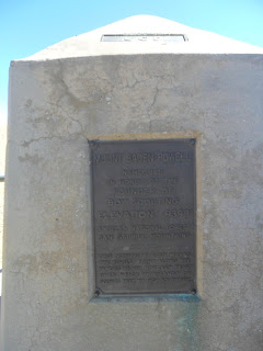
The Trail: From Crystal Lake campground parking lot, merge onto the Windy Gap trail. At the beginning of the trail there is a sign indicating trail mileages. You abruptly walk through Oak woodlands and chaparral, hot going on a warm summer day. All around you is evidence of the 2002 Curve Fire, and forest seems to be recovering very slowly. You will cross over two roads, one paved, another unpaved, and in 2.5 miles and 1,700' of gain arrive at 7550' Windy Gap, which true to its name is extremely windy. Here you meet the Windy Gap Trail Junction. A sharp left 0.8 miles to Mt. Islip, a left 0.3 miles to Little Jimmy Campground, and a right onto the Pacific Crest Trail, and your destination. From Windy Gap savor the views only possible in Southern California,: the vast Pacific and metropolis to the south, sublime forests around you, and the endless dry Mojave and Southern Sierra the the north. Enjoy these views for much of the hike, trying to pinpoint landmarks such as Downtown Los Angeles, San Clemente Island, and the Tehachapis. From Windy Gap you steeply walk on and around the ridges of the Middle High Country, passing wtill more damage from the Curve Fire in some places. On the southern side of the ridge the wind howls unceasingly, and on the north side, the wind is for the most part calm, and the forests are lush and healthy. over 1000' below you to the north in the Angeles Crest Highway-the only thing that reminds you of civilization. A large peak soon comes into views on the eastern skyline, a few miles away, but this is not Mt. Baden Powell, but Throop Peak. After a couple miles there is an unmarked trail split to Hawkins Ridge, and half a half further is a trail 100' to Mt. Hawkins summit. Immediately before you Mt San Antonio, the highest in the San Gabriels stands impressive above the steep canyon of the Sheep Mountain Wilderness. Closer you can see Mt. Baden Powell before you, seemingly so close. From that trail split, you wind gently around 9,138' Throop Peak, and soon if you keep you eyes open, a climbers path appears which climbs 150' to its summit. After short distance through the thick forest near Throop Peak, the trail begins descending over 300', passing a trail split to Dawson Saddle on the Angeles Crest Highway. Immediately after descending the ridge ins a series of switchbacks, the trail begins gaining the elevation you just lost. This part of the hike travels around the northside Mt. Burnham through a lovely Lodgepole Forest, and the trail again descends 100' down into a second valley on the east side of Mt. Burnham, where a climbers path can be found. Again you ascend and again descend a third valley. Then climb up to Mt. Baden Powell Junction at 9270', where a left takes you down 2200' in 4 miles to the highway (a good car shuttle option on the way back), and a right the an enormous Limber Pine Tree and the summit of Mt. Baden Powell. Go right, up extremely steep slopes, until you behold yourself on the very summit of the famed mountain, named after the founder of the Boy Scouts, Lord Robert Baden Powell. A summit register and an impressive monument mards the significant of this summit. Limber Pines cling to the peak, which at over 2000 years old are the oldest living things in Southern California. What an amazing thought that some of these trees began growing when God Himself walked the earth. The views from here a compelling thing to experience Starting straight in front of you on the summit: Santiago Peak and the Santa Ana Mountains, and the vast Inland Empire and San Gabrielvalley, San Clemente Island 110 miles away, Santa Catalina Island, the glistening Pacific with its traffic of tanker ships, Orange County and the Chino-La Puente Hills, Long Beach and the busy South Bay, the Palos Verde Peninsula, Los Angeles International Airport (look for planes flying BELOW you!!), Santa Monica Bay and mountains, Los Padres high country, Downtown Los Angeles, the endless San Gabriels with the antennae and observatories of Mt Wilson being the hallmark of the mountain view, the open Mojave and its cities, the Devil's Punchbowl (a So Cal version of Zion National Park), the Tehachipis and Southern Sierra, the vast Mojave, Victorvile to Joshua Tree National Park, the San Bernardino Mountains, the high country of
the San Gorgonio Wilderness Mt. San Jacinto, and finally the distantjo Palomar Mountain in San Diego County. And around you the San Gabriel Mountains, Writghwood, the High Desert, the peaks of the Cucamonga Wilderness, enormous Mt Baldy, and the sttep chasms of the Sheep Mountain Wilderrness and the San Gabriel River Canyon. WOW! Got all that? Go and expierience God's majesty for you self!! Just remember on the way back to pace yourself, for the upgrades. Blest Be the Lord of Creation!!! "Mountains and Hills Bless the Lord, Praise and Exalt Him above all forever "-Daniel 3
Blessed Mother Pray For Us! Saint Rose of Lima Pray For Us!
Los Angeles County.
PHOTOS:
 |
| From the Curve Fire |
 |
| To the Desert |
 |
| To Mt. Wilson |
 |
| Mt Baldy |
 |
| San Gabriel High Country |
 |
| First Views of Baden Powell |
 |
| Towards Mt. San Anotnio |
 |
| The Devil's Punchbowl and Valyermo |
 |
| The PCT Trail |
 |
| Shoulder of Baden Powell |
 |
| Limber Pines |
 |
| Summit |
 |
| Towards Throop Peak |
 |
| Sheep Mountain Wilderness |
 |
| Actual Summit |
 |
| Into the desert |
 |
| Wrightwood and Victorville |
 |
| OTHERS |
 |
| COUNTRY |
 |
| GOD |
 |
| SELF |
 |
| To the desert |
 |
| The Trail |
 |
| The Largest Limber Pine |
 |
| Down from Baden Powell |
 |
| Baden Powell Jct. |
 |
| View from Windy Gap |
 |
| End of the Hike |


Thank you.
ReplyDeleteThank You!!!!
ReplyDelete