 Coming from the south, Mount Langley is the first great beacon of the High Sierra; coming from the north it is the last stronghold of the mighty peaks passed. It is also the southernmost 14'er in both California and the entire nation. The peak, like many other Eastern Sierra summits, towers nearly 10,000' above the floor of the Owens Valley, and the view from the base is nearly as stunning as the view from the top. Because of its proximity to Mount Whitney, the highest point in the contiguous US, it is sometimes called "Whitney's Little Brother" on account of their similar geologic structure and formation history; though of course Langley is a full 500' shorter than the big bro 4.8 miles away.
The mountain is named after the renowned American astrophysicist and aviator Samuel P. Langley, the third director of the Smithsonian Institution. In 1871 famous Sierra climber Clarence King made the first recorded ascent climbing what he thought to be Mount Whitney. After his mistaken trek the peak fell into the shadow of nearby Whitney, going by several unofficial names now attached to other nearby peaks such as Cirque Peak, Sheep Mountain and Mount Corcoran. It was not until 1943, when the USGS stamped the summit name of Langley to it. Since then climbing it has been a pastime of California peakbaggers, with many others using it as a trainer for Mount Whitney (though in my opinion Whitney is a trainer for this).

I hiked it in a day-a very long day, 13 hours and 20 minutes to be exact. I started at 6:30 am and finished at 7:50 pm. I wasn't breaking any records, but I was faster than many of the other climbers. Unlike the Mount Whitney Trail, this route has many ups and down, and the upper sections have no clear trail, but a steep scramble. I choose the Old Army Pass route, because it shaves off 600' of elevation gain from the typical New Army Pass route. The downside is, it is only snowfree Late July-October. Backpack it, dayhike it, you choose, but I guarantee you it will be an exhausting adventure you will both enjoy and cherish.
Stats:
Category: Very Strenuous (Dayhike)
Miles: 22
Elevation Gain: 5000'
Location: Inyo National Forest, Sequoia National Park, Golden Trout Wilderness, John Muir Wilderness
Directions: HERE

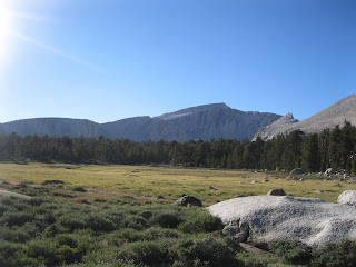
The Trail: Mount Langley has arguably one of the most scenic approaches of any California 14'er. From thick pine forests to wide open meadows, tranquil lakes to wind-sculpted ridges this trip has it all. All of the trip takes place above 10,000', but don't let that statistic fool you: it's no easy endeavor. From the Cottonwood Lakes trailhead (10,040', bathrooms, water, tent-campsites, bear canisters for overnight camping) take the obvious trail a few hundred yards to the entrance to the Golden Trout Wilderness, the namesake wilderness of California's state freshwater fish. After cresting a small knoll (10,200') the trail dips and swings up many times, making for a most unpleasant return at the end and adding about 400' of pointless elevation gain. In 1.5 miles time the roller coaster action is over for now, and the hiker will find himself in a quiet, dry Eastern Sierra forest, made up almost exclusively of lodgepole pine. To the left hangs the southern face of Flat Top, and to the right some verdant meadows and Cottonwood Creek. At this point you will be entering into the southernmost border of the glorious John Muir Wilderness, which stretches from here to just south of Mammoth Lakes. In another 2 miles and some more gentle climbing, a signed trail fork is reached (10,400'); take the right fork to Cottonwood Lakes, not to New Army Pass. Some real elevation begins now as you bench the 600' from the fork to the sub-alpine zone at 11,000': Cottonwood Basin.

Here in winter, uninviting winds howl over gale force and snow piles feet deep; but in the summer it is quite a different world. With its uncountable meadows, 20+ lakes and marshes, laughing streams, wallowing marmots, all topped by Mount Langley itself in the background, it would be a challenge to find a more inviting place in all the Sierra. Winding through the Cottonwood Basin I encountered uncountable numbers of marmots, a weasel, chipmunks, squirrels, and a herd of deer; Creation has indeed found a stronghold here. Follow the trail west across the meadows and forests, then dip 90' to impressive Cottonwood Lake # 3, perhaps the finest of the lot of lakes, and gain 120' to Cottonwood Lake #4 (11,100'). Here the main, maintained, and official trail ends, but strands of hikers going up Army Pass have blazed an excellent "unofficial trail" to follow. Speaking of Army Pass, yes that's it all right, towering over Lake #4 like a great impenetrable wall. Do not be discouraged though; although a bit rough, rugged and steep, the trail up is easy to follow. Take the trail west, along the lake, and past the last stand of trees 800' to the top of Old Army Pass (It took me 50 minutes to reach the top from Lake 4).
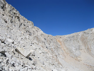
 Once atop (12,000'), there is a sign welcoming you to Sequoia National Park--what a sign with a sight! The view is excellent! Alpine tundra now dominates the landscape...as do marmots. The view east shows off some of the best of the Cottonwood Lakes Basin, and to the west, the Mineral King Country of Sequoia National Park. Take the obvious trail right from the pass (east), and this is where the hard part begins. Up until this point you have hiked 8.5 miles and gained about 2000'-- you will gain another 2000' in the next 2.5 miles-
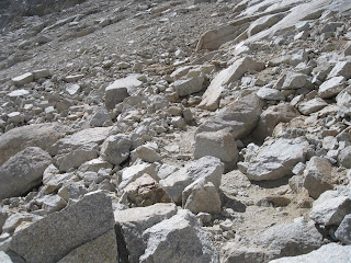
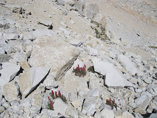
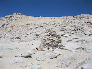
yes, that's about 4x steeper than what was just accomplished. Needless to say, take your time and watch out for altitude sickness, the side effects of which include persistent headache, nausea and other terrible stomach issues, very hard time breathing, and lethargy. Take that trail right and gain 300' quickly, before the tail again levels off and steadily jaunts for about 1 mile gaining only about 200'. Thence comes the use-switchbacks for 500'; take this part, again in patience. There is a sign posted by the NPS telling of new large 8' cairns designating the route to the summit. Follow the cairns. After the slog up to 13,200', the summit of Langley is clearer before you than ever before...seemingly so close. Take the main use-trail west as it dips about 20' to a very easy Class 2/3 section only about 20' high. From this point use the motto "Follow the Cairns" as your mantra-- beeline to them, wind to them, follow other use-trails to them, but whatever you do always follow the cairns in the northeastern direction. It is difficult to explain a Sierra Slog -- picture a slope at an angle of 1700'/mile, through loose sand and some small rock for 700' in the direct sun with 30 MPH winds in your face, and you get the picture. This is the definitely the crux of the trip. There are about 4 main cairns as beacons to the summit. From the last one, follow your senses to the highest point around 80' above you through easy terrain.
At last the summit attained! The view is astounding. Straight below you is a 5000' vertical drop to Tuttle Canyon, holding snow year-round, directly to the north stands Mount Corcoran, Mount Le Con, Mount Mallory, and then only 4.8 miles away, Mount Whitney and its pinnacles including Mount Muir. Past Whitney are other California 14'ers:
flat topped Mount Russell, triangular Mount Williamson, Mount Tyndall, lonely Split Mountain in the distance, and White Mountain across the valley. The great gash of the Owens Valley is at your feet, the deepest gorge in North America, while the wilds of the Mojave call to you. Southward is the local peaks of Cottonwood Basin, Cirque Peak and Trail Peak, and past them is Olancha Peak and the secluded Southern Sierra. Far past them are the San Bernardino and San Gabriel Mountain of Southern California, nearly 200 miles away. Western ways one sees the top of Ventura County, culminated on Mount Pinos 130 miles away, and then the magnificent Mineral King Country and Kaweaha sections of Sequoia National Park.
After spending some blissful time on the crown of this noble peak, return carefully the way back down the cairn-line to the use trail, down Old Army Pass, up 100' to the Cottonwood Meadows, down again to the Cottonwood Valley, and finally back up those grueling 400' back to the trailhead.
Mountains and Peaks, Forest and Pine, Weather and Cloud praise the Lord of Creation!
Date Climbed: 8/11/15. Inyo and Tulare Counties. No Dayhiking Pass Required.
High Altitude TIPS:
- Acclimate (AMS)! Spend the night before at the trailhead or backpack it. Better yet, take Diamox! Acetazolamide (Diamox®) taken 24 hours prior to arrival to altitude and the first 2 days at altitude is 75% effective in preventing AMS. It speeds up the acclimatization process in the body, stimulates breathing, raises blood oxygen and increases urination.
- HYDRATE! Drink even when you don't feel like it!!!! The more you drink the better you will feel. Your urine should be clear, if its not drink more water! Replenish also with electrolytes.
- EAT! Most people will not want to eat above 11,000', but do! You need that energy, or you will get sick!
- Know Your Limits! Severe headache? Persistent nausea? Fatigue? These are sign of Acute Mountain Sickness! GO DOWN!
- Pace Yourself! Take frequent breaks! Charging up the mountain will give you both fatigue and AMS for sure.
- Talk to other hikers coming down about the Trail! This is a great way to know current trail/weather conditions and meet new friends!
- Bring extra food/water/clothing! Honestly, if you don't know this rule, don't climb Mount Langley.
Recommended Prep Hikes:
1. One of the Three Saints of SoCal (Baldy, Jacinto or Gorgonio or any other High County Hikes above 8000'-these are always good trainer idea for altitude hikes)
2. Three Tees Trail (Preps for the ups and downs)
3. Jones Peak via Barebone Ridge (Preps for the final summit slog, though 1000' more on this trial.
4. Santiago Peak via Indian Truck Trail (Preps for the mileage)
5. Strawberry Peak (Preps for steep sections, off trailing, and Class 3)
 |
| The Trailhead 6:30 AM |
 |
| Golden Trout Wilderness |
 |
| The Trail at first |
 |
| First Meadows |
 |
| Corn Lilies |
 |
| John Muir Wilderness |
 |
| Trail Fork to Cottonwood Lakes and New Army Pass (Take CTTN) |
 |
| More Meadows |
 |
| Going up Cottonwood Lakes Trail |
 |
| Up More |
 |
| The Topof Cottonwood Valley |
 |
| Flat Top Mountain |
 |
| Cirque Peak (12,900') Left |
 |
| Marmot! |
 |
| Cottonwood Basin |
 |
| Cottonwood Basin and Mount Langley |
 |
| Lake 4 |
 |
| Take the split right to Old Army Pass |
 |
| Old Army Pass |
 |
| More Lakes as seen from on route to Old Army Pass |
 |
| Lake below Old Army Pass |
 |
| Trail up Army Pass |
 |
| More Tail..a bit rough, but fine |
 |
| The Lake from about 1/2 to the Pass |
 |
| Top of the Pass in insight! |
 |
| Alpine Flora |
 |
| A small, but easy rock bloackade. Swing 5. feet to the left and your over it |
 |
| Almost the Top! |
 |
| Top of the Pass 12,000' |
 |
| Cottonwood Basin from the Pass |
 |
| Path up from the Pass northwest |
 |
| Mr Marmot, King of Army Pass |
 |
| Backpackers slogging up the path |
 |
| Mineral King Country |
 |
| Mount Langley as seen from 12,400' |
 |
| The Western Sierra |
 |
| Getting Closer..... |
 |
| Alpine Terrain |
 |
| Hikers going up |
 |
| An 8' Carin |
 |
| The Cabin Fire (made for bad coughing) |
 |
| The Path up...follow those carins |
 |
| Following the Summit Carins |
 |
| One of the Carin getting closer.... |
 |
| The Last Carin in sight |
 |
| The Top! |
 |
| Almost There! |
 |
| Mount Whitney as seen from the Summit! |
 |
| The High Sierra |
 |
| How many 14'ers can you see? |
 |
| Upper Owens Valley |
 |
| Lone Pine Peak from Mount Langley |
 |
| Lone Pine and the Owens Valley |
 |
| Owens Lake (Dry) |
 |
| Mount Whitney and Mount Muir |
 |
| Cirque Peak, Olancha Peak...Do you see the San Bernardinos? |
 |
| Smoke as seen from summit |
 |
| Actual Summit! |
 |
| The Cliff |
 |
| Cliff to Tuttle Canyon!!! |
 |
| Cottonwood Basin from Summit |
 |
| Coming down Army Pass |
 |
| Mount Langley in the afternoon sun |
 |
| Cottonwood Valley |
 |
| Almost down..more unwanted uphill. Finish at 7:50 PM. |


 Coming from the south, Mount Langley is the first great beacon of the High Sierra; coming from the north it is the last stronghold of the mighty peaks passed. It is also the southernmost 14'er in both California and the entire nation. The peak, like many other Eastern Sierra summits, towers nearly 10,000' above the floor of the Owens Valley, and the view from the base is nearly as stunning as the view from the top. Because of its proximity to Mount Whitney, the highest point in the contiguous US, it is sometimes called "Whitney's Little Brother" on account of their similar geologic structure and formation history; though of course Langley is a full 500' shorter than the big bro 4.8 miles away.


 Once atop (12,000'), there is a sign welcoming you to Sequoia National Park--what a sign with a sight! The view is excellent! Alpine tundra now dominates the landscape...as do marmots. The view east shows off some of the best of the Cottonwood Lakes Basin, and to the west, the Mineral King Country of Sequoia National Park. Take the obvious trail right from the pass (east), and this is where the hard part begins. Up until this point you have hiked 8.5 miles and gained about 2000'-- you will gain another 2000' in the next 2.5 miles-


Solid write up! Great photos, congrats on the summit!
ReplyDeleteThanks for the timely trip report. I am climbing Mt. Langley on the 18th, so it is nice to see Old Army pass snow-free. Other than the rock blockage in your pictures, how was the rest of the trail up the pass?
ReplyDeleteGlad this report could help you out! The path up OAP was honestly steeper than I thought it would be, but not anything crazy. It is a bit rough and rugged...it is obvious and you can see it the whole time, but at the same time it is a bit narrow with some annoying rocks thrown in. Other sites say its really bad..its not. It took me 50 min from the lake to the top. Enjoy your trip and let me know how it goes!
DeleteWhat were temperatures like?
ReplyDeleteNot bad. When I got there at 615 am it was 48 F,most of the day it was 65-70 F from 10,000-12,500'. On the summit it was about 62 F with 20/30 MPH gusts here and there. Hope this helps!
DeleteNice job! Great pictures. There seems to be a lot less smoke than last month.
ReplyDelete