
 Peaks which rise near an urban area, as a rule, aren't typically the destinations of serious hikers or seasoned high country trekkers. I have usually found them somewhere ranging from casually boring to, when taken on a weekend, downright awful. Box Springs Mountain County Park on a cool winter weekday is an exception. Known to locals as the mountain stamped with an enormous "M" on its south side seen from miles away (standing for the city of Moreno Valley), the Box Spring Mountains rise a steep 2000' over Riverside, Moreno Valley, and the surrounding regions. In summer, when the smog is thick, the vegetation scorched, and the heat and exposure extreme, the range is a less than inviting place. After a series of cool winter storms, though, when the air is clear and offers expansive views across the Southland and soft layers of green grass, mosses, and reinvigorated scrub return to life, the Box Springs offer some of the finest urban hiking in the Inland Empire. This trip to the highpoint of the range, Box Springs Mountain, and a lower conical peak offering a Class 2 and brief Class 3 climbing challenge called Table Benchmark, enters the heart of the range near Pigeon Pass within these small mountains between Moreno Valley and San Bernardino.
Catagory: Moderate (Both Peaks), Easy (Just one of them)
Miles: 6.5
Elevation Gain: 1,400'
Location: Box Springs Mountain County Park ($5 fee payable at trailhead, cash/check only)
Directions: HERE (The Final 2 miles are dirt, but is suitable for any car.
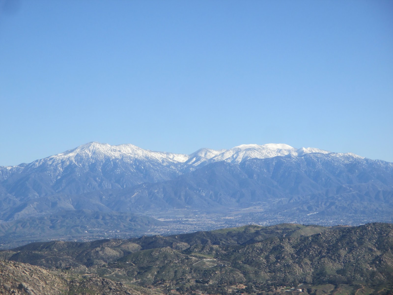
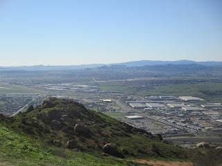 The Trail: Once at the trailhead, to reach Box Springs Mountain first begin walking south up the north slope of the hills and cross onto the Box Springs Mountain Fire Road. In a few hundred yards, you will reach a short-cut route called the Spring Trail. I took this route to both save time and enjoy a bit more of nature on this single track trail as opposed to the fire road. Follow the Spring Trail as it steeply makes gains over the north slopes of the local peaks, until it drops suddenly back onto the main fire road whereupon you will join the later once more. Continue climbing at a moderate grade up the fire road passing through the jumbles of rocks in the range (as you are at a convergence of multiple fault zones and geologic and hydraulic tables) surrounded verdant grasses and a revived heartier coastal sage scrub in season. Unfortunately in sections throughout the park, dishonorable characters have made it a habit of theirs to needlessly ruin nature by offensive graffiti; a most despicable act common in urban hikes. Keep an eye out for C-17's making landing approaches to nearby March Ari Reserve Base, flying below you! Reaching the crest of the range, you pass by radio tower after radio tower before making a final dip to ascent the summit proper, topped with none other than a large radio transmitter. A few more yards south you come to the popular lookout point above the signature piece of the range, the "M". Between this lookout and the summit proper, the views when clear are outstanding! Besides the immediate vistas of the Riverside and San Bernardino Metro Areas, it is truly the extremities of the views that are tremendous. In the east lies, the San Gorgonio Pass surrounded glorious summits of San Gorgonio Mountain and San Jacinto graced in their winter mantles Past it, the Little San Bernardino Mountains of Mojave and Sonora make their march toward the Salton Sea, south the hogback of the Palomar Mountains and the San Diego county coast ranges dominate, while the view west turns along the entire Santa Ana range. Still west, the Palos Verde Peninsula over the Port of Long Beach can be spotted, as can the Santa Monica and Verdugo Mountains, the backdrops of downtown Los Angeles. Finally northward stands Mount Wilson of the San Gabriel Mountains, which stretch all the way to the snow-streaked summits of Cucamonga and Ontario Peaks before dropping into the Cajon Pass. Take it all in, and when done return back the trailhead. This section is 5 miles roundtrip.
 If you are feeling the need for some more hiking, Table Benchmark certainly can fit the bill. It adds about 1.5 miles and a couple hundred feet more of gain. It is the unmistakable conical peak just north of the trailhead, which boasts a use trail and Class 3 summit block. To reach it, stay parked at the trailhead, but begin walking along the roadside for about a quarter of a mile, before turning to the use trail to the summit. Follow this very steep climber's path (sadly graffiti littered, which dies of though as you ascend...vandals are too lazy I suppose.) As you approach Table, the path becomes a Class 2 climb through a jumble of rocks before passing through a Sugar Sumac tree patch and rounds to the 10' tall Class 3 summit block. Pick your holds, and enjoy the view from the small summit you should have all to yourself. Return the way you came, only be careful not the slip on the natural gravel atop the slick granite.
Do not attempt on a hot day. There is no shade on this trail.
Riverside County, CA. Hiked 1/17/2017
 |
| Dirt Road Final 2 miles |
 |
| Trailhead |
 |
| Begining... |
 |
| Green pastures... |
 |
| Spring Trail cut off |
 |
| Looking north towrds Eastern San Gabriels |
 |
| Northside shadows |
 |
| Rejoining the Fire Road |
 |
| Expanding views south |
 |
| A steeper section |
 |
| Nearing the summit |
 |
| Summit of Box Springs Mountain |
 |
| View into Moreno Valley and Hidden Springs |
 |
| Santa Ana Mountain and thr 215-60 Interchange |
 |
| Towards Corona and Chino Hills |
 |
| Downtown Riverside |
 |
| Cajon Pass and the Mojave Desert |
 |
| San Gorgonio and friends |
 |
| Zoom in... |
 |
| San Jacinto Mountains |
 |
| Towards Highland (SB CO.) |
 |
| Palomar Mountains in distance... |
 |
| March Air Reserve Base |
 |
| The "M" |
 |
| Table Benchmark from Trailhead |
 |
| Use trail |
 |
| Steeper... |
 |
| Mushroom Rocks... |
 |
| Nearing summit |
 |
| Class 2...fun...eh. |
 |
| More Class 2 |
 |
| Sumac near summit |
 |
| Climbing up the Class 3 block |
 |
| View to Riverside from Table |
 |
| Pigeon Pass |
 |
| Wow! Box Springs Mountains in Winter... |
 |
| Cool! |
 |
| Burros on the Road! |
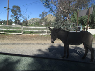 |
| Friendly driver... |


 Peaks which rise near an urban area, as a rule, aren't typically the destinations of serious hikers or seasoned high country trekkers. I have usually found them somewhere ranging from casually boring to, when taken on a weekend, downright awful. Box Springs Mountain County Park on a cool winter weekday is an exception. Known to locals as the mountain stamped with an enormous "M" on its south side seen from miles away (standing for the city of Moreno Valley), the Box Spring Mountains rise a steep 2000' over Riverside, Moreno Valley, and the surrounding regions. In summer, when the smog is thick, the vegetation scorched, and the heat and exposure extreme, the range is a less than inviting place. After a series of cool winter storms, though, when the air is clear and offers expansive views across the Southland and soft layers of green grass, mosses, and reinvigorated scrub return to life, the Box Springs offer some of the finest urban hiking in the Inland Empire. This trip to the highpoint of the range, Box Springs Mountain, and a lower conical peak offering a Class 2 and brief Class 3 climbing challenge called Table Benchmark, enters the heart of the range near Pigeon Pass within these small mountains between Moreno Valley and San Bernardino.
  The Trail: Once at the trailhead, to reach Box Springs Mountain first begin walking south up the north slope of the hills and cross onto the Box Springs Mountain Fire Road. In a few hundred yards, you will reach a short-cut route called the Spring Trail. I took this route to both save time and enjoy a bit more of nature on this single track trail as opposed to the fire road. Follow the Spring Trail as it steeply makes gains over the north slopes of the local peaks, until it drops suddenly back onto the main fire road whereupon you will join the later once more. Continue climbing at a moderate grade up the fire road passing through the jumbles of rocks in the range (as you are at a convergence of multiple fault zones and geologic and hydraulic tables) surrounded verdant grasses and a revived heartier coastal sage scrub in season. Unfortunately in sections throughout the park, dishonorable characters have made it a habit of theirs to needlessly ruin nature by offensive graffiti; a most despicable act common in urban hikes. Keep an eye out for C-17's making landing approaches to nearby March Ari Reserve Base, flying below you! Reaching the crest of the range, you pass by radio tower after radio tower before making a final dip to ascent the summit proper, topped with none other than a large radio transmitter. A few more yards south you come to the popular lookout point above the signature piece of the range, the "M". Between this lookout and the summit proper, the views when clear are outstanding! Besides the immediate vistas of the Riverside and San Bernardino Metro Areas, it is truly the extremities of the views that are tremendous. In the east lies, the San Gorgonio Pass surrounded glorious summits of San Gorgonio Mountain and San Jacinto graced in their winter mantles Past it, the Little San Bernardino Mountains of Mojave and Sonora make their march toward the Salton Sea, south the hogback of the Palomar Mountains and the San Diego county coast ranges dominate, while the view west turns along the entire Santa Ana range. Still west, the Palos Verde Peninsula over the Port of Long Beach can be spotted, as can the Santa Monica and Verdugo Mountains, the backdrops of downtown Los Angeles. Finally northward stands Mount Wilson of the San Gabriel Mountains, which stretch all the way to the snow-streaked summits of Cucamonga and Ontario Peaks before dropping into the Cajon Pass. Take it all in, and when done return back the trailhead. This section is 5 miles roundtrip.
  If you are feeling the need for some more hiking, Table Benchmark certainly can fit the bill. It adds about 1.5 miles and a couple hundred feet more of gain. It is the unmistakable conical peak just north of the trailhead, which boasts a use trail and Class 3 summit block. To reach it, stay parked at the trailhead, but begin walking along the roadside for about a quarter of a mile, before turning to the use trail to the summit. Follow this very steep climber's path (sadly graffiti littered, which dies of though as you ascend...vandals are too lazy I suppose.) As you approach Table, the path becomes a Class 2 climb through a jumble of rocks before passing through a Sugar Sumac tree patch and rounds to the 10' tall Class 3 summit block. Pick your holds, and enjoy the view from the small summit you should have all to yourself. Return the way you came, only be careful not the slip on the natural gravel atop the slick granite.


No comments:
Post a Comment