Mount Whitney
“Come and Let us Climb the Lord’s Mountain”-Isaiah 2:5

Mount Whitney, at 14,508’ above sea level, is not only the highest peak in the Sierra Nevada and the State of California, but also the highest mountain in the entire continental United States. Towering over 10,000’ above the arid Owens Valley floor, Mt. Whitney is the hallmark of the Eastern Sierra. Located four hours northeast of Los Angeles, this popular climb is attempted by over 30,000 people each year, making it the most sought-after summit in the country. Although only a third of the attempts are successful, those who conquer this peak claim it as one of the most memorable experiences in their lives. The hike poses no technical climbing routes, since there is a well-graded trail that leads to its summit. Almost anyone with a strong will to summit, a dedication to training, and proper gear, can attain the zenith of the mountain. Every American hiker must at least attempt to conquer one of the most sublime natural gems of the United States- Mount Whitney.
 The Stats:
Category: Very Strenuous
Milage: 22
Elevation Gain: 6,700’
Location: Inyo National Forest and Sequoia National Park.
Total Days: 3
Total Nights: 2
The Trail: After picking up your wilderness permit at the Inter-Agency Visitor Center in Lone Pine (3,700'), drive up the Whitney Portal Road 13 miles to the Trailhead of the hike (8,365'). Right from the beginning the trail loses no time in gaining elevation and soon you wind around large boulders through some pristine examples of Great Basin vegetation, including cactus, pinyon and junipers, Ponderosa and Jeffery Pines, as well as cottonwoods. The early sections of this trail are sun-exposed and unpleasant going on a warm day. In a brief time you make your first of many creek crossings, fording Carrion Creek and later, the more impressive North Fork of Lone Pine Creek. After 1 mile, you are welcomed into the John Muir Wilderness, arguably the finest wilderness area west of the Continental Divide. You begin switchbacking up through some sagebrush and pine-dotted hillsides, before arriving to the famous log-bridge crossing of Lone Pine Creek 2.6 miles from the start. Look for Golden Trout swimming about in the fast flowing stream.
 Soon after the crossing of Lone Pine Creek, you pass a spur trail to Lone Pine Lake at 9,900'. You continue straight though on the main trail and pass a sign telling you that you have entered into the Whitney Zone. From here you climb a few easy switchbacks, shaded by Foxtails and Lodgepoles, to Bighorn Park at 10,300'. Keep a lookout for deer and other animals as you meander around serene Bighorn Meadows and laughing Lone Pine Creek. At the end of the meadow, a large waterfall is before you and you find yourself at woodsy Outpost Camp, a delightful place to sleep for the night. (3.8 miles from the start, 10,400').
 Having left beautiful Outpost Camp and Bighorn Park, you climb some 200' to placid Mirror Lake (10,600'), teeming with wild trout. Stay and rest for a while here, as it is one of the finest stops on the trail. After Mirror Lake, you follow the trail upon slabs of granite and continue towards treeline at 11,000'. After parting with the last trees, you enter into the alpine country; where streams run unchecked, winds howl bitterly, and snow lingers year-round. Bring a good topo map and have a good sense of direction, for the section of trail from treeline to Trail Camp is rough and unimproved in spots, and many times, first-timers will find themselves charging off the established trail. Between treeline and Trail Camp is stunningly beautiful Trailside Meadows (11,300'),skirted by the pure waters of Lone Pine Creek's up-most reaches, blanketed by brilliant wildflowers and grasses in season and shadowed by great snowfields in the background. Above the quaint meadows the trail continues to climb past some springs and streams before detouring around some boulders, exposing outstanding views of Consultation Lake (11,670'). Past these boulders, the trail eventually finds itself at Trail Camp (12,000', 6 miles from the start), nestled near a small lake, perched high above treeline, and completely exposed to the elements. Above Trail Camp rise the impressive pinnacles leading up to Mount Whitney, 2000' above you. If you choose to spend the second night at Trail Camp, be prepared for gale-force winds at times. (strong enough to snap tent poles and ruin a night's rest)
 Above Trail Camp, you begin the feared "99 Switchbacks", which lead from 12,000 to 13,700' in 2.1 miles. The switchbacks for the most part, are easily graded, and the only three things you really need to worry about are: 1) Make sure your off of the switchbacks before 4 pm (as soon as the sun sets behind the Sierran Crest, the numerous springs on the switchbacks may freeze, causing very slippery conditions) 2. Altitude! Take it Slow! See my link on the side on Acute Mountain Sickness. 3. The Cables. The cables are located about half-way up the switchbacks near switchback number 45, and can hold snow well into July in some years. Bring Hiking Poles!
If you have made it to the top of the switchbacks, it is very impressive! You are now 8.1 miles from the start, and at 13,700' at Trail Crest. From the crest, you behold on of the great views of all creation; the unspoiled, virgin Sierran peaks, forests, and lakes on the western side of the range. A photograph does no honor is showing the true grandeur of this view from Trail Crest. Once at Trail Crest, you descend 300' to the John Muir Trail junction at 13,400'. Take the Whitney Trail up only 1.9 miles to the famed summit. Hence forth, you enter into the most inspiring part of the trip; completely barren, completely beautiful, and completely breathtaking. You wind around some grand minarets, traverse along the top of intimidating cliffs, and past "windows" in the pinnacles near the summit. Here you must truly use you judgment of your each and every movement. Winds can rip any time over 75 Mph, snow may fall at any month, and lightning can shake the high country to its foundations. Here you must muster up all of the knowledge, experience and respect of creation you have learned and put it into practice as you pace those last sections of trail to the summit. This work will not have been in vain.
 Standing atop Mount Whitney was almost like a dream to me; a dream I had lived mentally so many times- but to actually be there, foot on summit, wind in the face, and eyes down upon creation...perhaps there is not one word that can properly explain the feeling of living a dream. In the brief time upon that grand summit, sentiments of relief, joy, thanksgiving and trust came upon me, and I could not help but being drawn to praise the One who made it all... the Creator of the deepest desires of the human heart...the Creator of the good, the true and the beautiful.
Remember, the summit is only halfway there. Return safely, the way you came.
Saint John the Baptist, Pray for Us!
Sacred Heart of Jesus, Have Mercy on Us!
Hiked 6/24-26/2014. Inyo and Tulare Counties Highpoint.
Mount Whitney Permit Required.
TIPS:
- Stay together as a group! Most Search and Rescue cases happen when groups split up! I saw some of this on my trip!
- Acclimate (AMS)! Spend the night before at the Portal, Onion Valley, or Horseshoe Meadows. Better yet, take Diamox!
- HYDRATE! Drink even when you don;t feel like it!!!! The more you drink the better you will feel. Your urine should be clear, if its not drink more water! Replenish also with electrolytes.
- EAT! Most people will not want to eat above 11,000', but do! You need that energy, or you will get sick!
- Know Your Limits! Sever Headache? persistent nausea? Fatigue? These are sign of Acute Mountain Sickness! GO DOWN!
- Pace Yourself! Take frequent breaks! Charging up the mountain will give you both fatigue and AMS for sure.
- Talk to other hikers coming down about the Trail! This is a great way to know current trail/weather conditions!
- Bring Extra food/water/clothing! Honestly, if you don't know this rule, don't climb Mount Whitney.
MY PLAN AND GEAR
------------------------------------------------------------------------------------
Day-by-Day Breakdown
DAY 3: Miles: 15 (Trail Camp to summit and back to Whitney Portal Trailhead), Elevation Gain: 3,000', 6700' loss.
The Route:
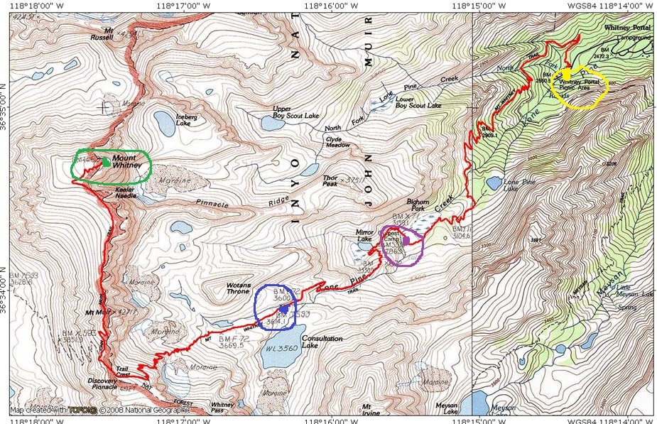
Legend:
The bright red line follows our entire route.
The Trailhead (yellow), is at the Whitney Portal. ELV. 8360’
Our first night was spent at Outpost camp near Bighorn Park (Purple) ELV. 10,400’
Night two was spent at Trail Camp (Blue) ELV. 12,000’
Mount Whitney (green) was our destination ELV. 14,505’
The Permit and Regulations
Because Mt. Whitney is such a popular climb, the US Forest Service has instituted a permit system in order to hike the Mt. Whitney vicinity. The Forest Service uses a ‘lottery’ program to choose who gets in. On February 1st, the lottery opens.
Also, because of the high use of the Whitney Area, the Forest Service has instituted the use of W-A-G (Waste Alleviation Gels) bags for solid waste to be packed out of the area and disposed of at the trailhead after the hike, instead of it being buried. These are paid for by your $15 per/person fee.
And, because of the California Black Bear, that inhabits the Whitney Area, bear canisters are required. NO food may be left in your car. You can rent these from the ranger station in Lone Pine, or a sporting goods store.
More Information:
Main Gear Needed: Tent, a sleeping bag that can keep you very warm, a sleeping pad, a sturdy backpacking backpack, water purification systems (filter or iodine tablets), extra warm clothes, rain gear, hiking shoes or boots, high calorie foods, gloves, beanie and hat, first aid kit, matches, medications for pain, Stove and burner, hiking poles, sunglasses
Weather in the Summer: High Sierra summer weather is highly unpredictable. It can be sunny and bright at 10 am and snowing with lightning at 12 pm. Even in the summertime, highs above 12,000’ struggle to get out of the 50s, and the nights are cold, almost always dropping below freezing, and as low as 20. High winds and monsoonal thunderstorms can also pose threats to hiking. The most common occurrence of weather in the summer is clear and cold mornings with thunderstorms in the afternoon. So, as I said earlier, bring lots of warm clothes and rain gear. Snow was on the trail when I went.
Hazards: In addition to unpredictable weather as formerly mentioned, altitude sickness can make a major part in mountain hazards. The best way to acclimate is to take hiking slowly and drinking lots of water as well as practicing hiking at high elevations, such as Mount Baldy and the San Gabriel Mountains high country (Baden-Powell, Cucamonga Wilderness), the San Bernardino Mountains (San Gorgonio Wilderness), and the San Jacinto Mountains (over 8000’). Acetazolamide (Diamox®) taken 24 hours prior to arrival to altitude and the first 2 days at altitude is 75% effective in preventing AMS. It speeds up the acclimatization process in the body, stimulates breathing, raises blood oxygen and increases urination.
----------------------------------------------------------------------------------
PHOTOS OF THE TRIP:
 |
| View from the visitor Center (103F) |
 |
| Trailhead Trout ponds |
 |
| Steep granite cliffs above |
 |
| The Beginning.. |
 |
| The famed wooden entrance |
 |
| Creek side beauty |
 |
| Welcome to the John Muir Wilderness |
 |
| Lone Pine Creek log crossing |
 |
| Through the Lodgepoles |
 |
| "Entering the Whitney Zone" |
 |
| Bighorn Park |
 |
| Outpost Camp Waterfall |
 |
| The next morning to Mirror Lake |
 |
| Outlet of Mirror Lake |
 |
| Mirror Lake (10,600') |
 |
| Meadows near the lake |
 |
| Trout in the lake |
 |
| Climbing above Mirror Lake |
 |
| The granite slabs |
 |
| a level stretch near treeline |
 |
| Above treeline |
 |
| Into the Alpine |
 |
| Above the chutes looking at Mirror Lake |
 |
| View into the Owens Valley |
 |
| The distant 11,000+ Inyo Mountains |
 |
| Trailside Meadows |
 |
| Above the meadows |
 |
| Consultation Lake, as seen from the trail |
 |
| climbing the stairs up to Trail Camp |
 |
| First snow patches |
 |
| Trail Camp (12,000') |
 |
| Trail Camp Pond |
 |
| Mount Muir (14,012') and the Pinnacles |
 |
| Sunset |
 |
| Camp (tent poles broke that night) |
 |
| The next morning climbing the switchbacks |
 |
| The valley between Wotans Throne (right) and Whitney (in clouds) |
 |
| Alpine Flowers |
 |
| The Cables |
 |
| View from 13,000' |
 |
| There it is! (See the summit hut?) |
 |
| The Owens Valley |
 |
| Nearing Trail Crest |
 |
| (Actually 13,700') |
 |
| The otherside of the Crest towards the western Sierra |
 |
| Hitchcock Lakes Basin and Sequoia NP |
 |
| Pinnacles above the crest |
 |
| Climbing the trail after the John Muir Junction |
 |
| Looking up a slope |
 |
| Winding around the pinnacles |
 |
| View from the windows |
 |
| View from another window |
 |
| View from the Whitney-Keeler Saddle (14,000') |
 |
| Keeler Neddle and Crooks Peak |
 |
| Final snow crossing |
 |
| Wow.... |
 |
| Final 0.25 miles to the summit! |
 |
| Summit Hut |
 |
| We are here!!!! |
 |
| Perfect weather on summit! |
 |
| Towards the Heart of the High Sierra |
 |
| Sequoia NP |
 |
| Kern River Gorge |
 |
| Mount Langley, Olancha Peak, and the very distant San Gorgonio Mountain |
 |
| Looking into Lone Pine |
 |
| Coming down |
 |
| John Muir Trail Junction |
 |
| At Trail Crest |
 |
| Climbing down the switchbacks |
 |
| The Cables |
 |
| Trail Camp Pond (L) and Consultation Lake (R) |
 |
| After Trail Camp |
 |
| The Last (or first?) tree! |
 |
| Mount Irvine above Bighorn Park |
 |
| Bighorn Park, late afternoon |
 |
| Deer in the meadows |
 |
| Switchbacks down into the Portal |
 |
| Looking towards Lone Pine from the final 3 miles |
 |
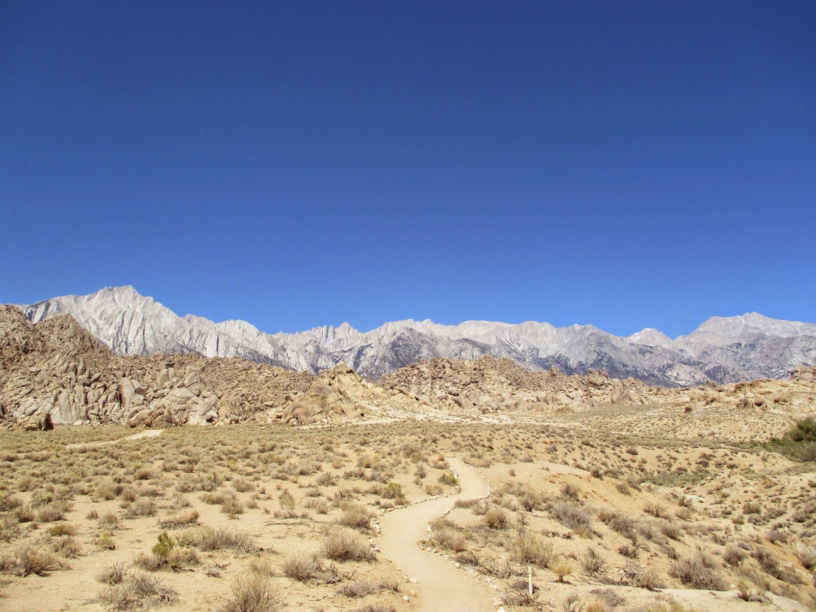
| The last view of Whitney from near the Trailhead. |
My Training Hikes (in order of dates) for Mount Whitney:
- Palomar Mountain State Park
- Potato Mountain
- Mount Lowe Railway Loop
- Ontario Peak
- San Gabriel Peak, Mount Disappointment, Mount Lowe
- Santiago Peak
- Henninger Flats
- Mount Baldy and West Baldy from the Village
- Tahquitz Peak
- Mulkey Meadows: Golden Trout Wilderness
- Mount San Jacinto
- Cucamonga Peak
Thanks to (helping to make this trip easier and safer): Dave and Tracy (Whitney Portal H&H), Doug Thompson (Whitney Portal Store), Bob R. (Inyo NF), Mount Whitney Forums, Hiker Dan, Iron Hiker, Joe the Hiker, and all the other amazing people I met on the trail. Thanks to all those who prayed for us! And, of course to my family, and mostly Our Savior, Jesus Chirst!
------------------------------------------------------------------------------------------------------
Schulman Grove of Ancient Bristlecone Pines (Discovery Loop)
Stats:
Miles: 1.5 miles
Elevation Gain: 300'
Location: Inyo National Forest (White Mountains)
Directions: Here
Description:
Here,
high in White Mountains of Eastern California, grow the oldest living things on earth, the Great Basin Bristlecone Pines. Some of these trees are over 4,700 years old! Come walk near these ancient trees of antiquity and ponder the sheer length of their lives.
The Trail: From the large, new visitor center (10,000'), take the trail at the far end of the parking lot and follow the signage of the Discovery Trail. You quickly gain some elevation, as you pass by both Lodgepoles and the venerable Bristlecones. Across from you stands the lofty Sierra Nevada, and the Palisade Glaciers, the southernmost group of glaciers in North America. Directly below you is the flat, sagebrush covered terrain of the valleys of the White Mountains, and around you stand the oldest living things on the planet. Take your time as you climb up, and switchback up the steep mountainside. Eventually the trail ends back at the parking lot.
 |
| White Mountain Peak (14,246') from Bishop |
 |
| Sierra View, off the road |
 |
| The Palisade Region and Glaciers |
 |
| The best view of the Eastern Sierra possible |
 |
| Flowering Cactus |
 |
| The Trail |
 |
| The Great Basin Bristlecone Pine |
 |
| Rohan? |
 |
| Talus slopes |
Alabama Arch
Stats:
Miles: 0.5
Elevation Gain: 100'
Location: BLM Alabama Hills
Directions, description: Here


No comments:
Post a Comment